


The Abyss and the Hadal Trenches
Below 3,000 metres lies the most common kind of surface on the planet, a cold, dark, flat plain fed by a thin rain of marine snow and the occasional dead whale. This unit describes what lives there and how, from the sea cucumbers that make up most of the animal mass to the giant single cells in the sediment, why life at 4,000 metres runs slowly and lives long, how a small molecule in the muscle of fishes sets the depth below which no fish is found, and what the baited cameras of the last fifteen years have shown in the trenches, including the deepest fish ever filmed and the plastic fibres inside the amphipods of the Mariana Trench.
Most of the solid surface of our planet is a flat, cold, dark plain of fine mud between 3,000 and 6,000 metres below the sea, and almost nobody has seen it. The animals that live there have never felt sunlight or a season, they eat what sinks to them from kilometres above, and they do so under a pressure that would flatten a submarine of the Second World War. Deeper still, in the trenches where one plate of the Earth’s crust slides under another, the seafloor drops to almost 11,000 metres, and fish stop at about 8,300 metres while crustaceans and sea cucumbers carry on to the bottom. This unit describes the abyssal plains and the hadal trenches as habitats, the thin and irregular food supply that reaches them, the animals that live on it, the biochemistry that lets them do so, and the twenty years of baited cameras that have turned the deepest places on Earth from a blank into a measured habitat.
1 The abyssal plains
The names of the depth zones were agreed in Unit 2 for the open water, with the bathypelagic zone from 1,000 to 4,000 metres, the abyssopelagic from 4,000 to 6,000 metres, and the hadal zone below. On the seafloor the boundaries are drawn a little differently, because the seafloor has a shape. The continental slope and the continental rise, the gentler slope at its foot, form the bathyal zone from about 200 to 3,000 metres, and the abyssal zone of the seafloor begins where the rise flattens out, at about 3,000 metres, and reaches to 6,000 metres (Figure 1). Below that lie only the trenches. The abyssal zone covers more than half of the Earth’s surface, so the abyssal plain, and not forest, grassland, or ice, is the most common kind of surface on the planet.
An abyssal plain is a seafloor so flat that its slope is often less than one metre in a thousand, which is flatter than any natural surface on land. The flatness is made by sediment. Turbidity currents, avalanches of mud that run down the continental slope, spread their load over the plains near the continents, and far from any coast the floor is covered by pelagic sediment that has settled out of the water column over millions of years. Much of it is ooze, a mud made mostly of the skeletons of plankton, and which kind lies where depends on what arrives from above and what survives the journey. Where little else arrives, the pelagic sediment is a red or brown clay of wind-blown dust and volcanic ash. Under productive surface water it is a calcareous ooze of coccolith plates and foraminiferan shells (Unit 3), but only where the floor is not too deep, because calcium carbonate dissolves in the cold deep water and the shells never reach the deepest floors. Under the polar and equatorial belts, where diatoms dominate, it is a siliceous ooze of diatom and radiolarian skeletons, which are made of silica and survive the descent. It accumulates at a rate of millimetres to a few centimetres per thousand years, which means that the top centimetre of mud under a submersible’s camera may have taken as long to form as the whole of recorded human history.
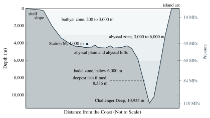
The abyssal water is cold and uniform. It sank from the surface of the North Atlantic or the Antarctic, as Unit 2 described, and it keeps its temperature for centuries as it spreads along the bottom. Most of the abyssal plains lie in water between about 1 and 4° C, with the coldest floors under the Antarctic-fed deep water of the Pacific and Indian oceans. The salinity is close to 34.7 grams of salt per kilogram of water everywhere. The oxygen is plentiful again below the oxygen minimum of Unit 13, because the bottom water still carries the oxygen it took up at the surface, and so little sinking organic matter reaches this depth that almost nothing is left to consume it. Nothing changes with the time of day or the season except the food supply of Section 2. The one property that does change, steadily and enormously, is the pressure.