


Shores, Mangroves, and Seagrass Meadows
The strip of coast that the tide covers and uncovers is the best studied habitat in the sea, and the experiments done there with barnacles, sea stars, and boulders gave ecology some of its central ideas. This unit explains why rocky shores are striped, what a keystone species is, how a tree can live with its roots in seawater, why a seagrass is a flowering plant and not a seaweed, and how mangroves, salt marshes, and seagrass meadows bury carbon faster than any forest on land. It ends with what satellites and old maps say about how much of these habitats has been lost.
Twice a day the sea leaves part of its floor in the open air and comes back for it. The strip of coast that is covered and uncovered by the tides is the only part of the ocean that a person can walk across, and for that reason it is the best studied habitat in the sea and the one in which many of the general ideas of ecology were first tested with experiments. This unit follows the coast from the splash zone down into shallow water, from the bands of barnacles on a rock face to the forests of mangrove and kelp and the meadows of seagrass, and it ends with the recent discovery that these narrow strips of vegetation bury more carbon for each square metre than any forest on land.
1 The coast as a gradient
1.1 The tides
The tides are the response of the ocean to the gravity of the Moon and, to a lesser degree, of the Sun. The Moon pulls more strongly on the side of the Earth that faces it than on the centre of the Earth, and more strongly on the centre than on the far side, and this difference in pull stretches the ocean slightly along the line to the Moon. The water on the near side is pulled towards the Moon a little more than the solid Earth is, and the water on the far side is left a little behind, so that the water stands a little higher both on the side facing the Moon and on the side facing away from it. The Earth turns under these two bulges once a day, and a point on the coast passes through both, which is why most coasts have two high tides and two low tides in a day. Because the Moon moves along its orbit in the same direction as the Earth turns, the Earth needs 24 hours and 50 minutes to bring the same coast back under the Moon, and the two high tides of a day are therefore 12 hours and 25 minutes apart. High water arrives about 50 minutes later each day, which is why a visit to the shore has to be planned with a tide table rather than a clock.
The Sun raises a tide of its own, about 46 per cent as large as the lunar one. At new moon and at full moon the Sun and the Moon pull along the same line and their tides add up, which gives the largest range between high and low water. These are the spring tides, a name that has nothing to do with the season and comes from the old sense of the verb to spring, to rise or swell, because the water springs up the shore. When the Moon is at its first or third quarter (the two half moons), the two pulls act at right angles and partly cancel, and the range is smallest. These are the neap tides. The cycle from one spring tide to the next takes 14.8 days, half a lunar month, and Figure 1 shows what it looks like at one place.
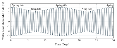
The tidal range, the height difference between high and low water, depends far more on the shape of the coast than on the Moon. In the open ocean the bulges are less than a metre high, and small islands in mid ocean see ranges of about that size. Enclosed seas such as the Mediterranean, which is connected to the Atlantic only through the narrow Strait of Gibraltar, have ranges of a few tens of centimetres. Along the coasts of north-western Europe the spring range is typically 4 to 8 metres. The record is held by the Bay of Fundy in eastern Canada, where the length of the bay matches the tidal cycle so that each tide pushes the water of the bay at its natural swing, in the way a child on a swing is pushed, and the spring range at the head of the bay reaches about 16 metres. On most Atlantic coasts the two tides of a day are of similar height (a semidiurnal tide, that is, a twice-daily one). Parts of the Gulf of Mexico and of south-east Asia have only one high tide a day (a diurnal tide, a once-daily one), and the Pacific coast of North America has two of clearly unequal height (a mixed tide). Every one of these patterns can be predicted years ahead by adding up a few dozen regular constituents of the kind described in the caption of Figure 1, which uses two of them.
1.2 Time under water and time in the air
For an animal fixed to a rock, the tide translates into one number, the fraction of its life it spends out of the water. The higher up the shore it settles, the longer it is exposed to air, heat, rain, and frost, and the shorter the time in which it can feed and breathe in water. If the tide rises and falls as a sine curve, this fraction follows from the height alone, and Figure 2 shows how: the animal is in the air whenever the curve of the water level lies below its height.